


Location based services using mobile and web application to gather and analyze spatial data is another area of our expertise.

We provide expertise in Remote Sensing Image analysis, GIS and Modelling. Satellite image processing and interpretation for various application such as agriculture monitoring, landuse change, and other environmental processes monitoring and mapping. We also provide service in spatial analysis and modelling using various geostatistics and modelling approaches.

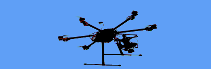
We specialize in UAV based photogrammetric application like DEM, Orthophotos generation and analysis, and providing LiDAR based solutions.
Check our works with different clients

Kathmandu Metropolitian City used mobile ans web apps developed by geospatial technologies to document traditional buildings and heritage sites.
The multi-rotar UAV was deployed in various areas of Kathmandu and Kavrepalanchwok to capture high resolution imageries. These images were used to prepare maps of disaster hit areas.

Geosphere Technologies is implementing cheap but cutting-edge technology to reconstruct 3D models of different heritage sites.